European Commission Executive Vice-President Maroš Šefčovič, Spanish Minister for Foreign Affairs, European Union and Cooperation José Manuel Albares and UK Foreign Secretary David Lammy, together with the Chief Minister of Gibraltar Fabian Picardo, met in Brussels earlier today.
The complainant in a Supreme Court rape trial was accused of “making things up” as she goes along, and was also accused of trying to “make money” from her alleged rapist, while she was cross-examined by the defence.
Robert Kessler is Program Manager for Maritime Global Data Solutions at Oceaneering International Inc., a leading global provider of engineered products and services. Oceaneering concentrates primarily on the offshore oil and gas industry, with a focus on deepwater applications, and the use of applied technology expertise to serve the defence, entertainment, material handling, aerospace, science, and renewable energy industries.
Please talk to us about your role and main responsibilities at Oceaneering:
As Program Manager for Maritime Global Data Solutions at Oceaneering International, I am responsible for the growth and delivery of our expanding solutions portfolio. This includes our Oceaneering PortVision 360 service for maritime intelligence, our Asset Monitoring Intelligence Center (AMIC) for remote monitoring to support asset protection and optimisation, and our Oceaneering TerminalSmart platform for liquid terminal logistics management. Another related offering is our Oceaneering Media Vault (OMV) offering, which solves the challenge of storing high volumes of archived media from remote operations – both onshore and offshore.
In your view, what is Oceaneering's competitive advantage in the industry?
From the perspective of the Global Data Solutions group that I represent, Oceaneering offers a unique combination of products and capabilities that are increasingly important for oil and gas operations upstream, midstream, and downstream, as well as a broader set of both wet and dry bulk cargo shipping operations.
We were an early pioneer in web-based satellite tracking and monitoring solutions that used Automatic Identification System (AIS) technology for vessel traffic management and collaboration. Our PortVision AIS-based vessel tracking service has helped lead the way to a new generation of comprehensive solutions that are now being used by major oil companies, marine service providers, vessel operators, and government agencies to enhance performance and revenues. It also underpins our TerminalSmart platform, which combines our latest PortVision 360 service with customised dashboards, collaboration features, and web-based real-time operational planning and reporting in order to significantly improve operations across petrochemical refineries, third-party terminals, and port authorities. The TerminalSmart platform has been proven to significantly reduce dock delay times by an average of 35% within the first few months of adoption and to deliver approximately 15% more vessel calls within the first year.
More recently, Oceaneering has enhanced its TerminalSmart enterprise-class marine terminal optimisation family to also provide planning, reporting, and forecasting capabilities across all terminal product transportation modes from the dock to tanks, trucks, rail, and pipelines. This includes everything from pipeline transfer scheduling, tasking, and line management functions to historical reporting for performance tracking, optimisation, and trending analysis. Our TerminalSmart platform remains the only liquid storage terminal optimisation solution with AIS vessel-tracking technology at its core.
Additionally, we can extend our solutions with a variety of additional Oceaneering capabilities, including our OMV (Oceaneering Media Vault) solution for archiving, retrieving, and analysing media footage from any location at any time, so users can more easily make decisions on day-to-day problems or on questions about assets and operations.
In general, our solutions solve some of today’s most difficult challenges through the collection, transmission, integration, analysis, and display of crucial data that help improve efficiency while enabling collaborative process monitoring, reporting, decision making, and key performance indicator (KPI) tracking and process optimisation.
Image Credit: Oceaneering International Inc.
What is PortVision 360?
The PortVision 360 Marine Asset Protection solution is an extension of the Oceaneering PortVision service, so that it now also includes the company’s shore-based AMIC, which gives owners of remotely operated fixed structures a round-the-clock “virtual watch team” for assessing threats posed by vessels to their multiple remote assets or large areas of subsea infrastructure, anywhere in the world.
The AMIC provides operators with a holistic view of what is happening around their global assets – they can protect their rigs and platforms from vessel collisions and unauthorised encroachments, and comprehensive vessel and location snapshot reporting provides information about each vessel, point-of-interest, or user-defined zone. GPS positions from AIS transmitters, radar targets, and other sensors are ingested into the AMIC data centre, and integration with satellite AIS delivers a complete offshore picture, enabling the PortVision 360 software to filter out false-negative alarms and send alerts about vessels’ interactions with the identified assets. Throughout the process, the collected data is also used to optimise operational efficiency and emergency response.
Our PortVision 360 service builds on 10 years of proven success for the company’s collaborative web-based vessel-tracking product line, extending its capabilities to make it even easier to answer questions and share information about vessel movements and events anywhere in the world. Key features include our patented Insight analysis engine, which gives users a better understanding of dynamic vessel tracks; a Vessel Intelligence feature, which provides access to over 50 additional data attributes on 10,000 workboats and offshore support vessels; and expanded reporting against a data warehouse of 100 billion vessel arrivals, departures, passings, and individual vessel movements.
How has AIS evolved over time, and, applying today’s technology, how do we utilise this information?
When our PortVision service debuted a decade ago, it quickly proved its worth for enhancing vessel, port, and terminal efficiency, while reducing costs and improving safety and security. Leveraging real-time and historical AIS data and, later, radar and other data inputs, PortVision was used to centralise logistics management in the oil and gas industry, and this service has enabled tug and vessel operators to significantly reduce standby time at docks and terminals. Users have achieved these accomplishments during a period of unprecedented growth in crude oil transportation traffic, and, now, this AIS-based tool is poised to deliver new and better ways to improve visibility and efficiency, while also protecting vessels and the assets they navigate around as the industry enters its next wave of traffic growth and evolution.
One of the most important evolutionary developments has been the transition of the PortVision 360 service beyond simple vessel tracking into comprehensive offshore asset protection with our AMIC solution. This delivers a significantly more cost-effective, reliable, and consistent way to protect infrastructure from vessel threats with remotely located round-the-clock active watch teams. Early detection is too critical to be a secondary or even tertiary crew responsibility, or to be compromised by alarm fatigue. A better approach to more intelligent and effective risk mitigation requires: 1) access to data for each defined vessel risk, 2) a risk-monitoring platform that combines data sources into a shared display and can issue customized threat alerts based on each asset’s unique risk profiles, 3) a clearly defined set of risk assessment and mitigation procedures, and 4) dedicated and properly trained staff that can validate risks and initiate mitigation.
Outsourcing these elements to the Oceaneering AMIC centralised monitoring service ensures that professionals experienced with vessel operations are all using the same procedures, processes, and tools across the asset infrastructure. The team understands each asset’s specific risk profile and procedures, and knows how to interpret vessel movements and triggered PortVision 360 alarms. Their training and standardised operating procedures are always improving, and they apply best practices across all assets. Operators with multiple assets in the same region can take advantage of the AMIC network’s data sensors across their infrastructure to cover data gaps if a radar or other sensor fails. Using the PortVision 360 service with the Oceaneering AMIC enables users to monitor, assess, mitigate, and measure the risk of vessels impacting their assets, while improving visibility and transparency, strengthening safety and security, and generating higher-value operational insights.
Image Credit: Oceaneering International Inc.
What are the advantages of using a digital platform to improve port efficiency?
Oceaneering digital platforms have improved efficiency as vessels move to and from terminal docks, and they also improve port operations in other ways, leveraging the approximately 1 billion position records per month that the PortVision service ingests from every major port and waterway across the globe. Two examples are safety and vessel emissions control:
Safety: At Port Fourchon, Louisiana, our PortVision service was used to demonstrate the benefits of using AIS data in a digital platform as part of a major initiative to protect pipelines, the mariners who operate near them, and the environment surrounding them. In partnership with the Greater LaFourche Port Commission and Oceaneering, the Coastal and Marine Operators (CAMO) group demonstrated a safety broadcast system that transmitted AIS safety messages directly to mariners in two charted pipeline corridors near the port, significantly improving their situational awareness by providing immediate visibility about imminent threats and alerting vessels in danger of a possible pipeline strike. The system used AIS data to monitor vessel activities around pipelines and other infrastructure, alerted stakeholders when there was danger, and generated the actionable analytics necessary for risk assessment and asset management resource allocation and other decisions. To implement the marine safety and pipeline alert system, Port Fourchon and Oceaneering incorporated all pipeline maps into the PortVision vessel-tracking tool. Based on each specific pipeline segment, alerting parameters and criteria were determined and built into the solution, including vessel speed in or near zones of interest and duration of time spent near the pipeline segment. These and other variables can be problem indicators that should be scrutinised.
Emissions Monitoring: Another example of the benefits to ports of using digital platforms is generating in-port ship emissions data. The Australian Marine Environment Protection Association (AUSMEPA) is using the Oceaneering PortVision service to facilitate the operation of an online portal that will enable users to access emissions data of individual vessels at berth, at anchor, and at a port’s boundary. The solution leverages the PortVision 360 service’s ability to create geofences and real-time alerts, while also performing emissions calculations and generating emissions rating data, creating emissions layers on the main vessel-tracking map, and feeding the resulting information into an emissions dashboard that enables users to drill into data for ports, points of interest, and individual vessels.
How can big data help provide efficiency in shipping logistics?
Advances in data analytics and machine learning have allowed our team to really dig into seven years of historical vessel data and to dig out correlations that may not have otherwise been unearthed. For understanding the correlation of port congestion with weather events on the other side of the globe, our goal is to leverage our data in a way that businesses will know where their vessels or cargos are in real time, and to provide transparency to empower them to make informed decisions that increase efficiencies across the entire maritime supply chain.
What are the risks of subsea oil and gas operations, and how does your technology mitigate these challenges?
Our PortVision 360 service and our AMIC address these risks head-on.
As background, oil rigs and other fixed offshore assets faced many threats in the marine environment. They are vulnerable to collisions from vessels and to unexpected equipment failure, as well as health, safety, and environmental (HSE) hazards. These and other risks can be mitigated by identifying and prioritising operational risks at each site and understanding their environmental and financial impacts, and by applying smarter ways to manage and optimise the performance of widely dispersed assets in harsh and hard to monitor offshore environments. In the past, operators have typically set a radar “guard ring” and associated alerting mechanisms, so there would be a notification when vessels drew to within a set distance from the asset. Unfortunately, high volumes of false radar alarms from the assets’ own support vessels often desensitised watch teams. Plus, there was no way to incorporate the approaching vessel’s speed into the alarm trigger. Setting a ring large enough to account for fast-approaching vessels often overwhelmed watchstanders with false alarms, while too small a ring did not allow adequate mitigation notice.
Our PortVision 360 service and our AMIC solve this problem. The PortVision 360 service ingests all required GPS positions from AIS transmitters, radar targets, and other sensors, and integrates them with a satellite AIS for a complete offshore picture. Then, our shore-based AMIC provides a 24/7 “virtual watch team” for monitoring this data and assessing asset threats anywhere in the world. The disparate data sets are aggregated and transported to the AMIC to deliver centralised visualisation and actionable intelligence.
Image Credit: Oceaneering International Inc.
Five years from now, where do you see Oceaneering?
Our acquisition of PortVision a few years ago has expanded our vessel tracking capabilities and maritime domain expertise. The datasets we currently manage can allow us to deliver some very rich intelligence that will help cargo owners make better decisions to increase efficiency around the transport of cargo. Oceaneering, at its core, is a robotics company that specialises in harsh environments. We started with subsea remotely operated vehicles (ROVs) in the 1970s, and have branched out to non-tethered autonomous factory floor transport robots and trackless amusement park rides. I see Oceaneering expanding its expertise further into the maritime sector. We currently provide Underwater in Lieu of Drydocking (UWILD) surveys using our ROV fleet. It is not a stretch to see Oceaneering moving into the autonomous shipping realm.
Please describe your most memorable shipping experience:
One winter, when I was on the Mormac Star in the north Atlantic, I looked back and saw the stern deck taking on green seas where I had just been standing. That was the moment when I understood that the sea is truly in control.
What is your favourite ship?
As an engine cadet of the United States Merchant Marine Academy (Kings Point, 1988), I had the privilege of being part of the crew on the Genevieve Lykes, in her twilight years. Even then, the engine room was spotless. The ship was a traditional breakbulk ship with heavy lift capability. We went around the world stopping at ports in the Indian Ocean and the Far East before returning via the Panama Canal.
The Ministry for Economic Development, Telecommunications and GSB is hosting the Commonwealth data forum, the first Commonwealth Telecommunications Organisation (CTO) event to be held in Gibraltar, at the University.


 Jennifer Muñoz has signed up for the Miss Gibraltar pageant. She is the first candidate to put her name down for the competition.
 By Paul Gonzalez-Morgan
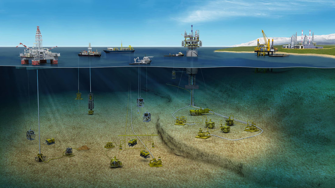
 Image Credit: Oceaneering International Inc.
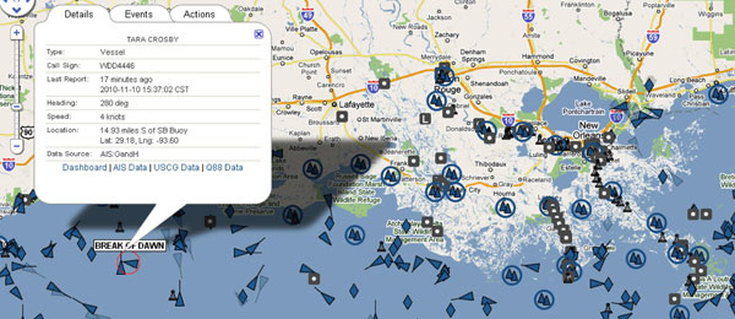 Image Credit: Oceaneering International Inc.
 The Ministry for Economic Development, Telecommunications and GSB is hosting the Commonwealth data forum, the first Commonwealth Telecommunications Organisation (CTO) event to be held in Gibraltar, at the University.